First, I'm going to break this up into multiple blog entries. It's just too much to put into one blog post.
This post will be about routes between Oahu and Maui, north and south of Molokai, taking into consideration the whale season. The real Humpback whale season begins in the next 2 to 4 weeks. The Act. 2/E.O. "whale season" begins in January when the whales are all already here. But, for now, we will focus on the routes.
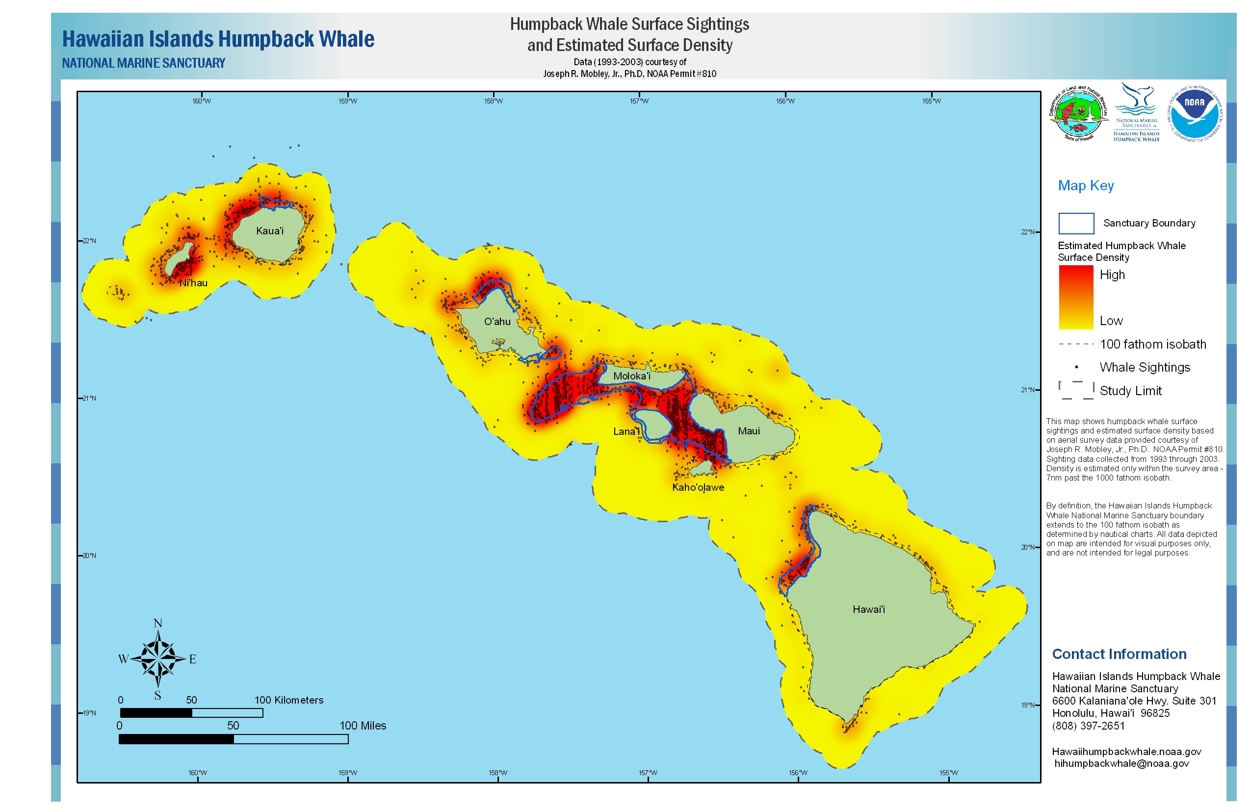
First, some pictures. The first graphic is from NOAA's website and was prepared by Dr. Mobley (advisor to Belt Collins RRA/EIS and previously DOT/HSF) and is of the Pacific Whale Sanctuary showing whale densities. Notice the large arc of whale density south of Molokai (click here to enlarge):

Next are a couple of pictures of HSF's North and South (alternate) routes. One from the Honolulu Advertiser and the other from HSF (click on source to enlarge):


Notice the routes that HSF uses above. Now, from Greg Kaufman's PWF presentation to the Ferry OTF on 9/19/08, notice the maps on pages 5-9 from that report (Slow 36 MB report) leading to the page 9 proposed alternate Southern route around the bulk of whale sitings by HSF of last April. Greg mentions the benefits of this alternate route avoiding much of the whale activity while "adding only 13 miles" (20 to 30 minutes) to HSF's transit.
Now, here is the really interesting thing found on this matter since the OTF meeting. Check out the following document: http://www.scribd.com/doc/415644/Hawaii-Superferry-Presentation. It is titled "Hawaii Superferry" dated June 19, 2006. It appears to be a DOT presentation to the community, but it also appears to have HSF developed information in it. In particular, look at page 81 of this document. It is a map prepared by Dr. Mobley either for HSF or for the state. It is titled, "We Change Routes During Whale Season To Avoid Whale-Dense Areas." Further it says, "Whale season routes go around Penguin Banks and North of Molokai." The route lines that are drawn on that map/chart on page 81 show a Southern route very similar to what Greg Kaufman/PWF more recently proposes that HSF begin using.
So, a question. This proposed Alternate Southern route that goes around Penguin Banks and the whale density in the sanctuary, that Dr. Mobley drew 2 years ago, and which Greg Kaufman rediscovered recently using HSF observation data, why hasn't HSF been required to use it all along when taking the Southern route during whale season?
More to come from the OTF Meeting,
Aloha, Brad


No comments:
Post a Comment